February 11, 2016
MWDL’s Best Practices for Geospatial Metadata Creation now available
If you’re interested in having your digital collections materials show up on the map interface provided on the Digital Public Library of America portal, start planning to add geospatial metadata to your records! The Mountain West Digital Library Geospatial Discovery Task Force spent many months reviewing different options, and now Best Practices for Geospatial Metadata Creation for MWDL Cultural Heritage Digital Repositories and the companion document, Instructions for Assigning Geospatial Metadata Using GeoNames.org, have been approved by the MWDL Digitization Committee and are available for MWDL partners to use.
 |
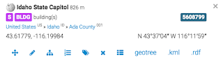
| GeoNames data for Idaho State Capitol. |
The new MWDL documents are on the “Policies and Guidelines” page on the MWDL website. Please feel free to point people to the page or to the particular links above and on the page in any of your websites or documents. We want to continue to get the word out about these valuable standards.
We were delighted to see the recent Geographic and Temporal Guidelines that the Digital Public Library of America released about geospatial metadata in DPLA. It looks like the MWDL Task Force’s documents are well in line with DPLA’s Guidelines — not too surprising, given the high level of coordination MWDL’s task force had with DPLA staff throughout our work!
Congratulations again to all task force members on fine work. An especial big thanks goes to the co-facilitators of the Task Force: Liz Woolcott from Utah State University Merrill-Cazier Library and Kristen Jensen from the Utah Department of Heritage and Arts. The strength of what we have produced together is the best example of why we all collaborate.


No Comments